Where to walk
The LOHP is committed to open public access to its sites, and to promoting quiet enjoyment of the countryside. A network of permissive footpaths has been created, which link with existing rights of way and quiet lanes to create routes for walkers and naturalists. Many of the fens are unfenced, but on grazed sites, we have installed wide gates to allow easier access for special needs.
A high resolution copy of this map is available (see below)
We run a programme of guided walks, cycle rides and open days to help introduce people to the valley's fens and their wildlife.
Access
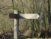
Permissive path signs
LOHP has an open access policy and welcomes visitors to the sites that it manages. Paths are provided to ensure easy and safe access and to minimise damage to sensitive wildlife. Please note:
- Permissive paths are almost always open but discretionary closures are possible.
- The Angles Way long-distance path passes along the south side of the valley.
- Each site has interpretive information sited on wooden tree sculptures; these include a map of each site.
- Cycling and horse riding are not permitted because of the damage they cause to the soft, peat footpaths.
- Please park your car with care - do not obstruct local access or cause damage to roadside verges.
For more detailed access information, please refer to the individual site pages.
Dogs
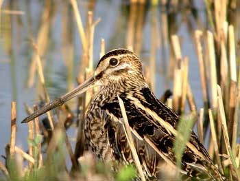
Ground-nesting Snipe
Well-behaved dogs are a joy to their owners and don't necessarily damage wildlife. We welcome responsible dog owners on our sites, especially when birds are not nesting or feeding, but a couple of problems have come to light. On Betty's Fen, Hinderclay Fen and along the riverside path fouling is a problem so please do pick up anything your dog leaves. On Scarfe Meadows recently we had a case of dogs being allowed to run freely across the site. If this was to become a regular practice then the uncommon birds that we hope to attract - like snipe - would not stay and feed here.
Please keep dogs under close control on our sites at all times - and keep them on a short lead when cattle or sheep are present.
Further afield
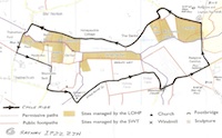
Cycling circuit
Most of the Little Ouse Project is enclosed within a 5 mile circuit of quiet roads including part of the national cycle route from Kings Lynn to Lowestoft and part of the Angles Way for walkers. Both of these connect into national networks of cycle routes and paths. This circuit is packed with enchanting history and wildlife heritage interest so its easy 5 miles can take as little or as long as time allows.
On the map above, the minor roads (in yellow) are designated 'Quiet Lanes' and are ideal for cycling. The minor road on the south side of valley is part of National Cycle Route 30 (Two Rivers).
In News from the Ouse, Issue 4, Spring 2012 Bob Hayward, LOHP Trustee and keen cyclist, shares his route around the LOHP sites.
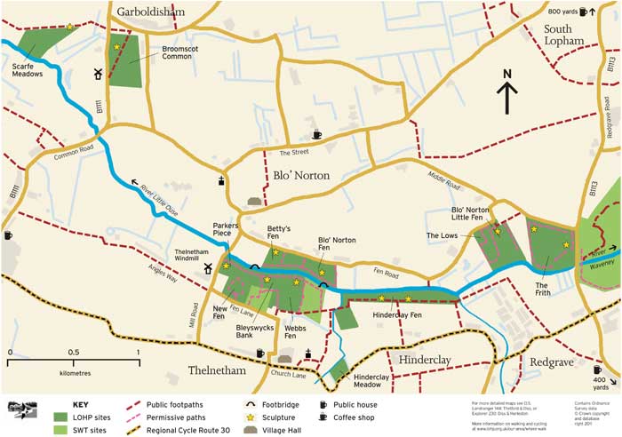
Maps
The following maps are available - please note that the high resolution files may be large:
- LOHP High Resolution Footpath Map (
 1.1 MB) as published in News from the Ouse, Issue 16, Summer 2016
 - Cycle route in the LOHP area ( 561 KB) as published in News from the Ouse, Issue 4, Spring 2012
The area is covered by Ordnance Survey maps:
- Landranger 144: Thetford & Diss
- Explorer 230: Diss & Harleston
Or create your own personalised map using the OS getamap service.